Flood Elevation and Letter of Map Amendment
 Plisga & Day have assisted hundreds of clients with property on or adjacent to the Maine Coast, inland lakes, rivers and streams. Are you in the flood zone?
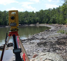
If you are close to the flood zone and when you use bank financing to purchase a home, camp or cottage or to construct a new building, often the first work product requested by your lender is a FEMA Elevation Certificate. The Elevation Certificate requires survey measurements for locating the lowest or most flood prone elevations of an improvement on a property such as the basement of a house, camp floor or slab of a garage. The difference between the structure’s elevation and the Base Flood Elevation will determine flood insurance requirements and the rates used by a lender. Upon our inspection, sometimes the improvements are above or not “in” the flood zone and a Letter of Map Amendment form is completed to remove the structure or parcel from the flood zone map. The Elevation Certificate and Letter of Map Amendment forms require services that involve research into the local FEMA flood map, a site visit for measuring elevations and office time to analyze elevations, fill out the FEMA forms and finally submit the forms directly to your lender or to FEMA for processing. If you have questions and need more information, or your bank is talking about an Elevation Certificate please contact us today and perhaps we can assist with finding out how close or far away you are from the flood zone.
Our service will be tailored to inspect your specific situation and provides the support information to you and your lender. The requirement for you to purchase flood insurance is always at your lender’s discretion.
Capabilities:
- Elevation Certificate
- Letter of Map Amendment
- Flood Elevation in Zone A
- Establish a Site Elevation Benchmark for New Construction
- Transfer Elevations for Reference Benchmarks
- Aid in Flood Study Elevation and Cross Section Mapping
Plisga & Day presented this “Mapping in the Zone A” slide show at the 2012 Spring Meeting of MSLS.