Portfolio
Boundary Lot Retracement
 A boundary retracement survey presents, in plan form, the relationship between recorded property descriptions with physical features on the ground such as boundary monuments, houses, driveways, water bodies, roads, and topography. A typical boundary retracement survey is a four-part project consisting of document research, field location, drafting and analysis, and boundary marking.
Large Tract Boundary Plat
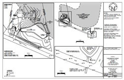
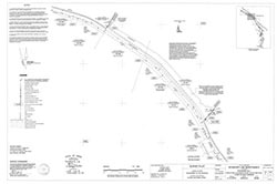 Boundary surveys are not all small lots. Plisga & Day retraces boundaries for large tracts of land such as this project for the National Park Service at Acadia National Park. This sample shows a boundary line retraced over several miles in Bar Harbor, Maine. Only one page of the seven page planset is shown.
Assessor Map or Tax Map
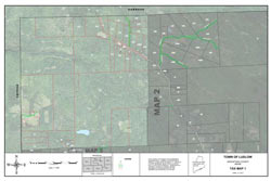 Muncipal assessor maps or tax maps roughly depict the lots within the town. This particular example shows the lots with an aerial photo backdrop for a portion of Ludlow, Maine.
Interactive Boundary Survey
 Boundary surveys can be quite complicated with multiple easements or servitudes across the property. The sample for the Islesford Museum includes several right of ways and a grave site. The PDF plan includes links to additional documents in the same PDF. Open this plan and try out an interactive map that links the map to source documents. Can you find the 1952 aerial photo? Try the PDF Bookmarks too.
Sample_BoundaryInteractive-Islesford-Museum
Elevation Certificate and Letter of Map Amendment
 Financing a property near the flood zone usually requires an Elevation Certificate that might necessitate a Letter of Map Amendment to remove a property from the flood hazard area. Properties near the flood zone with or without and an established Base Flood Elevation require measurements tied to the National Datum. In addition to FEMA forms filled out, additional site information is sometimes required such as shown in this Exhibit to a LOMA application.
Sample_LOMA-Exhibit
Site Plan
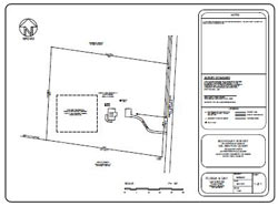
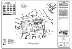 A Site Plan is a boundary retracement survey, generally of a commercial site, modified to include municipal building restrictions, parcel dimensional requirements, proposed construction plans and restricted areas such as wetlands. A Site Plan is generally prepared for a municipality to ensure proposed developments will conform to specific codes and zoning requirements. This site shows the proposed kitchen addition to a Tri-City Pizza in Bangor, Maine.
Sample_SitePlan_Tri-City-Pizza
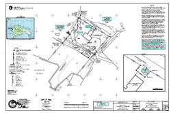
Planning Map
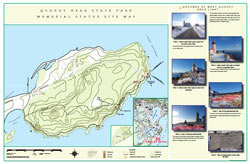 Pictures can be useful when added to flat maps and sometimes can be used as the map. This example shows a proposed monument site, see the red hatch, to be located at the Quoddy Head Lighthouse in Lubec, Maine. The locus map shows the surrounding peninsula and directions of views were inspected.
Sample_Planning-Quoddy-Head
Regional Planning Map
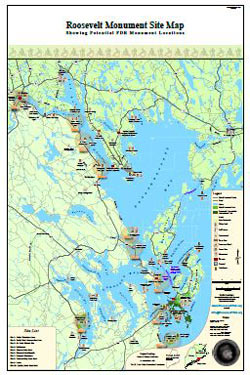 This example shows a proposed regional trail system with several monument sites proposed along the route. This is a large file (4.2Mb) and may take a minute to load in your browser.